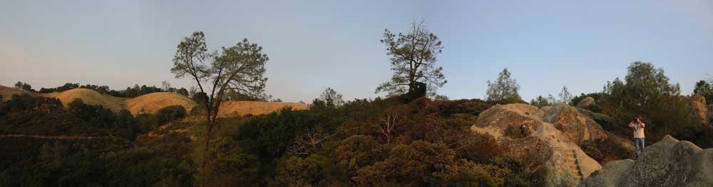
THAT’S MY FRIEND MAC over there with the binoculars, on the right; I’m afraid you can’t see him very well, as this is a pretty big photo much shrunk. (Click on it to see it bigger; and thank you, Photoshop merge.)
We’re up at the Live Oak campsite on the southwest flank of Mount Diablo, the highest mountain in the San Francisco Bay Area, where we slept before taking a trek over to the North Peak the other morning. In late September, on a weekday, the park is pretty well unpopulated — perhaps partly because one of the two access roads, the one from the north, was closed for repaving.
We saw almost no one except for bicyclists. Curiously, many of them were veterans, grizzled and tough, and riding alone. You can’t help wondering what motivates these guys (the few women cycling were younger): are they riding up into the sunset? It’s not an easy climb, and the descent is worse: I did it once, at least thirty years ago, and can still remember my aching hands from the constant braking on the way down.
Those days are over, but walking’s still in the mix, and Mac and I have a very undisciplined program of getting to the area’s high points. We began this a year ago with a stroll up the fire road leading to the top of Mount St. Helena, our local mountain. That’s 4344 feet high, the highest peak in the area, and it was a clear evening when we did it, and the views were extraordinary.
Mount Diablo is lower, at 3849 feet; but its isolated position makes it seem higher. Like Mount St. Helena it sports not one but two peaks, making them seem to be volcanic in origin, though they are not: they’re both upthrusts through older volcanic-origin rock — but also sedimentary stuff.
(A few months ago I said to myself and whoever was listening, probably no one, Thank God I’m not interested in geology. The very next day Therese presented me with a birthday gift: Doris Sloan’s Geology of the San Francisco Bay Region. Discovering it in its wrappings I couldn’t help exclaiming Oh wonderful! How fascinating! And of course it is fascinating, that’s why I’ve resisted geology all these years, there’s only room for so much fascination in one lifetime...)
We camped, Mac and I, at a low-elevation site in what’s called Rock City, which is not a city at all but a site about the size of a village, studded with interesting sandstone formations — Mac’s standing on one in the photo, and stair-steps were cut into another beyond him by the Civilian Conservation Corps back during the Depression, I guess, in a better time, when Government helpfully paid the unemployed to improve the public facets, physical and cultural, of the country we all live in.
We’d had a fine big lunch in Berkeley, so after our late-afternoon explorations of the rocks we contented ourselves with bread and cheese and chocolate for dinner, chasing away the occasional hopeful raccoon, and turned in about ten o’clock of a fine starry night.
Next morning after coffee and camp-breaking we had a visit from the park ranger, an affable man about fifty who had a lot to say about the park... we ran into him twice more, at the ranger station halfway up to the summit, then again at the summit. He’s a self-described Marxist, and was apologetic about the closed summit museum, blaming the anti-tax mood of the public as much, I think, as the priorities of the state government. Hard to argue with that.
On his advice we parked at Devil’s Elbow, a mile or so short of the summit, and set out on foot for the North Peak. This is a short hike, only a mile and a half, but involving a six- or eight-hundred change in elevation — downhill to a junction, then uphill to the summit. At its steepest the trail is on scree, and the last hundred yards or so was quite steep, approaching a twenty-degree climb, I’d say — hard enough going up; harder still descending.
Alas the sky was not clear. We saw further the previous evening at twilight, when we could make out Mount St. Helena, Mount Tamapais, Mount Hamilton and Copernicus Peak, as well as Grizzly Peak and Round Top among the Berkeley Hills.
The day began with fog in the valleys below us; we were on one of many islands of hilltop above this huge sea of fog — perhaps how things will be once the polar ice caps have melted and the sea level has risen. The fog burned off, but smoke from the Day Fire, and perhaps another up near Auburn somewhere, hid the Sierra and even nearer mountains — we never saw St. Helena, for example.
But we were compensated by the colors and textures of the slopes. All the wildflowers were gone except a number of patches of bold red California fuschia (Zauschneria californica) at their peak, and scraggly fleabane (Erigeron divergens) well past theirs.
Many of the south-facing slopes were covered with what I call chaparral, and Mac, more accurately but completely casually, calls chamise — a word which, curiously, appears in none of my English-language dictionaries. Adenostoma fasciculatum is what it is, commonly called greasewood, a wonderful fuel for the sort of fire now raging in Ventura county. It must have been magnificent when in bloom a few months ago, but it’s equally beautiful at the moment, glowing red-green in the evening sky, and forest green in the late morning, and adding a fine deep layer of texture to the gold of the dry grass, the feathery Coulter pines, and the occasional groupings of blue oaks.
Like the summit of Mount St. Helena, that of the North Peak is disappointingly crowded with communications towers bristling with relay parabolas and various radio and cell-phone antennae. It’s amazing to think of the energy and money responsible for installing and maintaining these things. It’s fun, though, to think of them as carrying on the tradition of Olympian energy-distribution from mountaintops known to all people close enough to the earth to be aware of the mysterious power of peaks.
People say the Indians were superstitious because they worshiped Mount Diablo, our ranger friend told us; That’s ridiculous; they worshiped it because it is sacred. It’s a very special place, and it’s the center of this part of the world.
I couldn’t argue with him. Mount Diablo is to the Bay area what Mount Shasta is to its area; it dominates the land around it, presses it down flat, but reaches up to mediate land and sky. And when you sleep on its flank, and walk or hike its trails, you appreciate the quantity and diversity of the forms of life it sustains — including, for a few fine hours, us ourselves.
Photos of our day on Mount Diablo can be seen by clicking here.
No comments:
Post a Comment